Helmand

Information Helmand
Helmand also known as Hillmand, in ancient times, as Hermand, Hirmand, and Hethumand is one of the 34 provinces of Afghanistan, in the south of the country.
It is the largest province by area, covering 58,584 square kilometres (20,000 sq mi) area.
The province contains 18 districts, encompassing over 1,000 villages, and roughly 1,446,230 settled people. Lashkargah serves as the provincial capital.
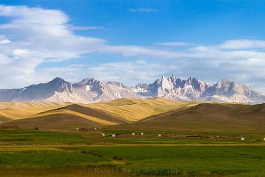
The Helmand River flows through the mainly desert region of the province, providing water used for irrigation. The Kajaki Dam, which is one of Afghanistan's major reservoirs, is located in the Kajaki district.
Helmand is believed to be one of the world's largest opium producing regions, responsible for around 42% of the world's total production.
The province has a domestic airport (Bost Airport), in the city of Lashkargah that was heavily used by NATO-led forces.
The former British Camp Bastion and the U.S. Camp Leatherneck is a short distance southwest of Lashkargah.
Who lives In Helmand?
As of 2020, the population of Helmand Province is about 1,446,230. It is mostly a tribal and rural society, with the ethnic Pashtuns being predominant; there is a significant Baloch minority in the south, and there is small minority of Tajiks, and a significant minority of Hazaras in the far northern regions of the province.
The Pashtuns are divided into the following tribes: Barakzai (32%), Nurzai (16%), Alakozai (9%), and Eshaqzai (5.2%).
All the inhabitants practice Sunni Islam except the small number of Hazaras who are Shi'as and the Sikhs who follow Sikhism.
Of the population, 53.5% lived below the national poverty line.
Get in
Air Travel
Bost Airport serves Lashkargah (capital of Helmand) and is about 600km (373mi) as the crow flies from Kabul, with a flight time of roughly 1 hour 14 minutes.
Domestic carriers such as Kam Air and Ariana Afghan Airlines operate flights from Kabul to cities like Herat, Mazar-i-Sharif, and sometimes Kandahar, but regular flights directly to Helmand or Lashkargah may not run reliably or frequently as of early 2025.
Road Travel
The road distance from Kabul to Helmand is approximately 690-693km, with a typical driving time of 11½ to 12 hours, depending on conditions.
The route generally follows the Ring Road via Kandahar, then west into Helmand.
Road infrastructure has improved in many stretches—especially parts like Kabul to Ghazni or Kandahar—but other segments remain in poor condition, with potholes or rough patches.
See
• Kajaki Dam
• Helmand river
• Lashkar Gah
• Historic Bost Castle
• Lashkari Bazar
Best places to visit in Helmand
1. Kajaki Dam:
The Helmand River in Afghanistan is primarily known for its two major dams: the Kajaki Dam and the Kamal Khan Dam.
The Kajaki Dam, a large earth and rockfill dam, is a major source of hydroelectric power and irrigation for the region.
The Kamal Khan Dam, while smaller, has also raised concerns about water sharing between Afghanistan and Iran.
Location: Kajaki District, Helmand Province, Afghanistan.
Purpose: Hydroelectric power generation and irrigation.
Capacity: 1,715×106 m³ (1,390,373 acre⋅ft).
History: Construction began in 1951, and it was completed in 1953.
Significance: It was part of a broader development project for the Helmand Valley, including irrigation, land development, flood control, and resettlement of nomadic families.
Current Status: Operational, with a power station that has two 16.5 MW and one 18.5 MW Francis-type turbines.
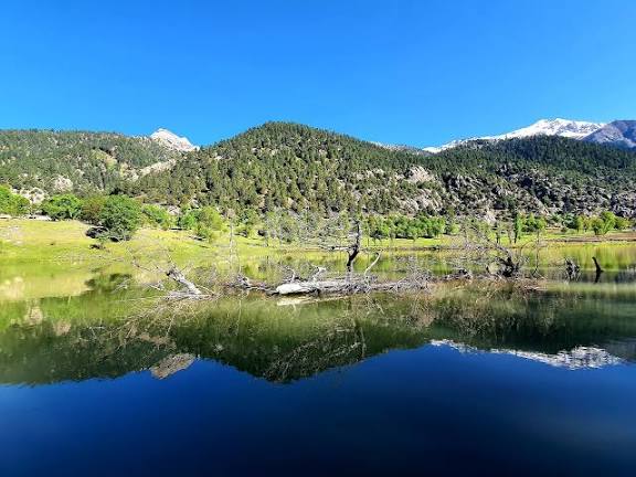
2. Helmand River:
The Helmand River is the longest in Afghanistan, originating in the Hindu Kush mountains and flowing southwest into the Sistan Basin, ultimately draining into Lake Helmand on the Afghan-Iranian border.
It is a vital water source for both Afghanistan and Iran, particularly for agriculture and irrigation, but has also been a source of conflict and dispute between the two countries.
Key features of the Helmand River:
Length: Approximately 1,150 km (710 miles).
Source: Hindu Kush mountains, about 80 km west of Kabul.
Course: Flows southwest through Afghanistan, eventually entering Iran and emptying into the Helmand swamps.
Drainage: Drains a large portion of southwestern Afghanistan, including the provinces of Wardak, Uruzgan, Helmand, and Nimruz.
Tributaries: Receives several major tributaries, including the Arghandab, Tarnak, and others.
Endorheic Basin: The river flows into the Sistan Basin, which is an endorheic basin, meaning it has no outlet to the sea.
Water Use: Crucial for irrigation in both Afghanistan and Iran, with a long-standing dispute over water rights.
Development: Has been the focus of irrigation projects, including the Helmand Valley Authority and the Kajaki Dam.
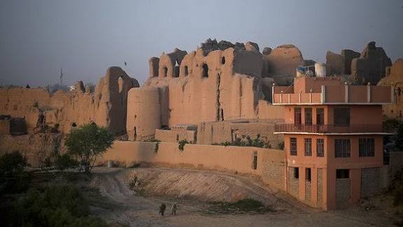
3. Lashkar Gah:
Lashkargāh also known as Lakhkargah, and historically known as Bost or Bust is a city in southwestern Afghanistan and the capital of Helmand Province.
It is located in Lashkargah District, where the Arghandab River merges into the Helmand River. The city has a population of 201,546 as of 2006.
Lashkargah is linked by major roads with Kandahar to the east, Zaranj on the border with Iran to the west, and Farah and Herat to the north-west.
Lashkargah means place of the army, from Persian words lashkar or lashgar (army) and gah (place).
Historically, it served as a military garrison, especially during the Ghaznavid Empire, when it was a winter capital and strategic military base. Its name reflects this military role.
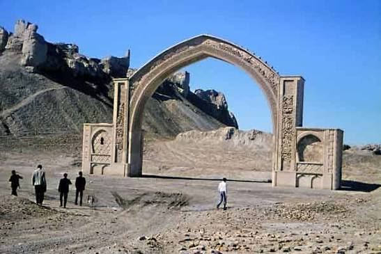
4. Historic Bost Castle:
The Fort of Bost, locally referred to as Qala-e-Bost (Dari: قلعه بست; Pashto: بست کلا), is a fortification near Lashkargah in the Helmand Province of Afghanistan, which is believed by some to have been built approximately 3,000 years ago.
It has been visited by many locals and foreign tourists throughout history. The archaeological site covers an area of around 10 kilometers (or 8 miles).
The Qala-e-Bost fortress in Helmand was primarily built by Ghurid rulers following their conquest of the city in 1149.
However, the site had been fortified previously, and the Ghaznavids also played a significant role in its development in the 11th century.
The Fort of Bost, also known as Qala-e-Bost, is an ancient fortress located near Lashkar Gah in Helmand province, Afghanistan.
It's a significant historical site, believed to be around 3,000 years old, with remnants of various civilizations, including the Ghaznavid and Ghori periods.
The fort is known for its strategic importance as a winter capital and commercial center, and for its decorative arch, which is featured on the Afghan 100-Afghani note.
5. Lashkari Bazar:
Lashkari Bazar (Persian: لشگری بازار "military market", locally known as Persian: کھنه قلعه Qala-e-Kohna "Old castle") was a palatial residence of rulers of the Ghaznavid Empire, located in Lashkargah in Afghanistan.