Maidan-Wardak
Information Maidan-Wardak
Wardak or Wardag (Dari/Pashto: وردک), is one of the 34 provinces of Afghanistan, located in the central region of Afghanistan. It is divided into eight districts and has a population of approximately 500,000.
The capital of the province is Maidan Shar (Maidan City), while the most populous district in the province is Saydabad District. Wardak is known for one of its famous high peak mountain known as (Shah Foladi).
Maidan Wardak province is located in the central and eastern region of Afghanistan; bordering Parwan to the northeast, Kabul and Logar to the east, Ghazni to the south and Bamyan to the west.
The capital of Wardak province is Maidan Shar, which is located about 35 km from Kabul. Wardak province covers an area of 9,934 km2. It is mountainous like the rest of the country with plains and many valleys, such as the Tangi Valley.
The majority of its residents live in rural areas. The most heavily populated areas are along the Kabul–Kandahar Highway. The rest of the province is thinly populated, with villages concentrated in areas with available irrigation and water sources (CSO and UNFPA, 2003).
Famous passes include the Unai Pass and the Hajigak Pass.
Who lives In Wardak?
The province is predominantly Pashtun and Hazaras with Tajiks making up most of the remainder of the population. The Tajiks live primarily in northern districts of the province while the Hazaras live in the western part of the province and the Pashtuns live in the south and east.
The province also has a small population of Qizilbash Because of its tall hills and narrow paths, traveling to Nuristan can be a little hard. But once you arrive, the peaceful land and friendly people make it all worth it.
Get in
Only by Road:
To reach Wardak Province, also known as Maidan Wardak, from Kabul, you can take a shared minibus or taxi from Kabul's Bamyan Terminal to Behsud, Maidan Wardak, or drive directly from Kabul. The journey is approximately 147 km and takes around 2 hours and 34 minutes by car or taxi.
See
• Jalrez Valley
• Historical Sites of chak district
• Chak River or Dam
• Tangi Valley
• Saydabad District
• Mullah Khel Maidan Wardak
1. Jalrez Valley:
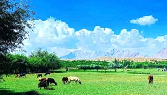
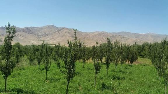
Jalrez district, also known as Jalrez Valley, is located in the west of Maidan Shar, Maidan Wardak Province, Afghanistan. It is a 37-kilometer long valley with several secondary valleys, situated southwest of Kabul.
Rivers: Includes the Sarchashma River, the Sanglakh River, and the upstream part of the Kabul River.
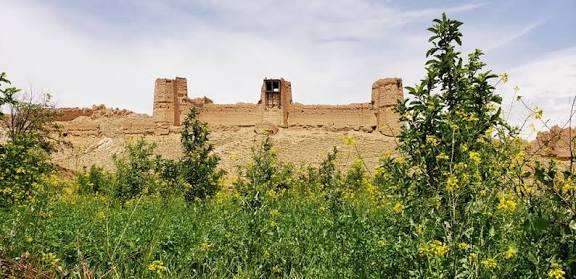
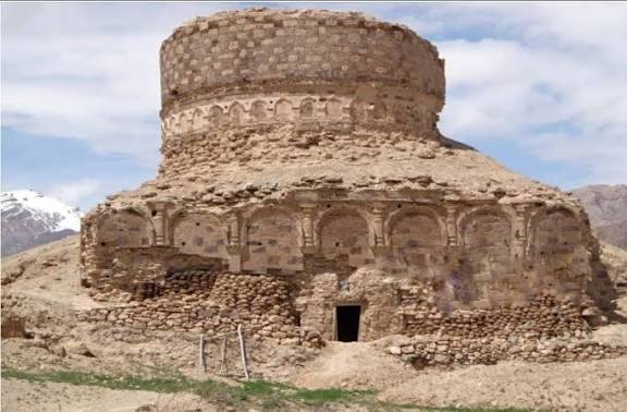
2. Historical sites of Chak District:
Wardak province in Afghanistan boasts several historical sites, including forts, shrines, mosques, and stupas dating back to the Kushan period.
Some notable sites include the Goda Naha Barja fort, Baskmand Hussain fort, and the former King Mohammad Zahir Shah hotel, though many have been damaged.
The province is also home to the historic Jalrez Valley, known for its fertile lands and vibrant markets.
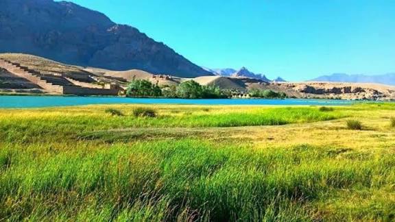
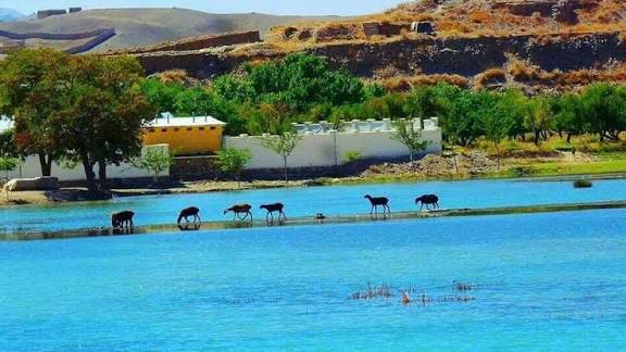
3. Chak dam:
Chak Dam, also known as Band-e Chak, is a hydroelectric gravity dam located near Chak in Maidan Wardak Province, Afghanistan. Built by German engineers in 1938, it was designed to regulate the Logar River and provide electricity to Kabul. The dam is also a source of irrigation water for the Chak Valley.
4. Tangi Valley:
Tangi Valley (also known as Wardak Valley or Tangi Wardak) is located in the south of Wardak Province in Afghanistan. Between 2009 and 2011 it was occupied by US forces, and became known for the large number of US troops killed there.[1] It was considered an important area and hence was a focus of insurgent activity due to its proximity to Kabul, the capital of Afghanistan.
The 2011 Chinook shootdown took place in the Tangi Valley. The day was the single biggest loss of US lives in Afghanistan.
By 2014, the Taliban had taken over the valley, with the central government at the time no longer having presence or control.
5. Mullah khel Maidan Wardak:
Mulla Khel (Mullā Gul Khēl) is a locality in the Chak-e Wardak district of Maidan Wardak province, Afghanistan. It's situated at an elevation of 2,242 meters and is close to other areas like Kōḏay and Tāchah. Maidan Wardak province, where Mulla Khel is located, is known for its rugged mountains, lush valleys, and strong Pashtun traditions.
The province is a historical crossroads for trade and migration, and its people are known for their resilience and hospitality.
6. Sayedabad District:
Saydabad District (Pashto: سیدآباد ولسوالۍ) is a district of Maidan Wardak Province, Afghanistan. The district is known for its pleasant climate, including hilly vegetation, streams, and orchards.
The city of Saydabad serves as the district capital. With a population of 114,793, it is the most populous district of the province. The district is within the heartland of the Wardak tribe of Pashtuns.
Eat and Sleep:
Despite its natural allure, Wardak is less frequented by tourists, offering a unique opportunity to explore Afghanistan off the beaten path. The local people are known for their hospitality and are eager to share their customs and traditions with visitors. When visiting Wardak, tourists can enjoy a blend of breathtaking scenery, cultural experiences, and the warmth of Afghan hospitality.
Note:
While there might not be dedicated tourist hotels in the same way as in major cities, it is possible to find accommodation options in Maidan Wardak, You can explore options like hotels near landmarks like Mullah Khel, or look for hotels with free cancellation policies.